Earth and Space Sciences Regents, August 2026, question 10
Tap an image to open it full size.
What the figure shows
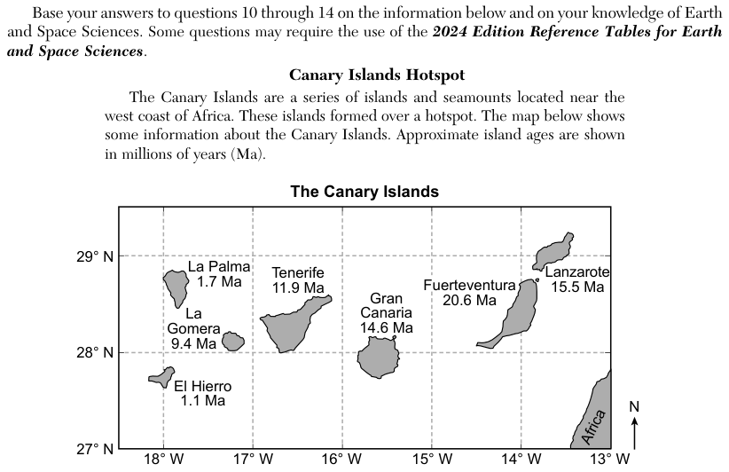
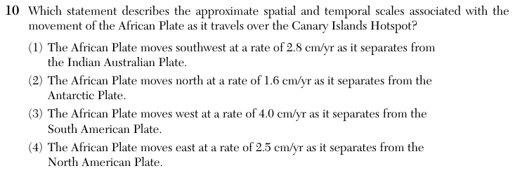
The passage says the Canary Islands formed over a hotspot near the west coast of Africa. A map titled The Canary Islands shows the islands between 13 degrees W and 18 degrees W longitude and between 27 degrees N and 29 degrees N latitude, with approximate ages in millions of years (Ma): El Hierro 1.1 Ma, La Palma 1.7 Ma, La Gomera 9.4 Ma, Tenerife 11.9 Ma, Gran Canaria 14.6 Ma, Lanzarote 15.5 Ma and Fuerteventura 20.6 Ma. The coast of Africa is at the lower right corner, and an arrow marks north. Each choice gives a direction, a rate in centimeters per year (cm/yr) and a neighbouring plate.
How to think about it
A hotspot stays in one place while the plate above it moves, so the youngest island sits over the hotspot today and older islands have been carried away from it. Use the island ages and their longitudes to find the direction the plate is moving. Then open the Global Tectonic Activity of the Last One Million Years map, find the divergent boundary on the African Plate at about the latitude of the Canary Islands, and read the plate on the other side and the spreading rate printed there.
Which statement describes the approximate spatial and temporal scales associated with the movement of the African Plate as it travels over the Canary Islands Hotspot?
Choice 4 is right. The island ages give the direction and the order of motion. The youngest islands, El Hierro (1.1 Ma) and La Palma (1.7 Ma), are in the west, and the oldest, Fuerteventura (20.6 Ma), is in the east, so the African Plate is carrying the islands east, away from the hotspot. The rate comes from the tectonic map. There, the Mid-Atlantic Ridge at about 28 degrees N separates the African Plate from the North American Plate, with a spreading rate of 2.5 cm/yr. The map gives the total spreading rate across the ridge, and the question treats it as the speed of the African Plate over the hotspot.
The island ages increase toward the east, so the plate is not moving southwest. The Indian-Australian Plate lies on the far side of Africa, in the Indian Ocean, and is not the plate the African Plate is separating from near the Canary Islands. This choice may come from reading a rate printed elsewhere on the map.
A rate of 1.6 cm/yr appears on the Southwest Indian Ridge between the African and Antarctic Plates, far to the south and east of the Canary Islands. The island ages also show eastward motion, not northward motion.
The rate of 4.0 cm/yr is printed on the Mid-Atlantic Ridge in the South Atlantic, where Africa separates from the South American Plate. That boundary is far south of the Canary Islands. Westward motion would also put the oldest islands in the west, which is the opposite of the map.