Earth and Space Sciences Regents, August 2026, question 44
Tap an image to open it full size.
What the figure shows
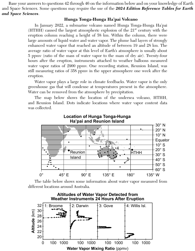
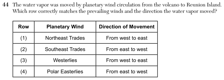
A map titled Location of Hunga Tonga-Hunga Ha'pai and Reunion Island shows latitude from 30° N to 60° S and longitude from 0° to 135° W. The volcano, labelled HTHH, is at about 20° S, slightly east of the 180° line. Reunion Island is at about 21° S, about 55° E, east of Africa. The passage says Reunion Island measured high water vapor ratios in the upper atmosphere one week after the eruption. The choices are rows of a table pairing a planetary wind with a direction: (1) Northeast Trades, from west to east; (2) Southeast Trades, from east to west; (3) Westerlies, from west to east; (4) Polar Easterlies, from east to west.
How to think about it
Find the volcano and Reunion Island on the map and note the latitude of each and which one is farther east. Then open the Model of Generalized Planetary Wind Belts in the Troposphere on page 19 of the reference tables, find the wind belt at that latitude, and check which way its arrows point.
The water vapor was moved by planetary wind circulation from the volcano to Reunion Island. Which row correctly matches the prevailing winds and the direction the water vapor moved? Row Planetary Wind Direction of Movement
Choice 2 is right. Both the volcano and Reunion Island lie at about 20° S, between the Equator and 30° S. The wind belt model on page 19 shows the Southeast Trades blowing there, with arrows pointing from east toward west. Reunion Island, at about 55° E, lies far to the west of the volcano near 180°, so the winds in this model carry air from the volcano toward Reunion Island, from east to west. The model is simplified: it is based on latitude and shows winds in the troposphere. The real plume was high in the atmosphere and was carried by the winds at its own altitude, which the model does not show.
The Northeast Trades blow between the Equator and 30° N, in the Northern Hemisphere, and both places are in the Southern Hemisphere. Trade winds also blow from east to west, not west to east.
The Westerlies of the Southern Hemisphere blow between about 30° S and 60° S, south of both places at about 20° S. This choice may come from thinking of the winds over New York, which do blow from west to east.
The Polar Easterlies blow near 60° S to 90° S, close to Antarctica, far south of the volcano and Reunion Island. The direction east to west is right, but the wind belt is wrong.